
 Washington, D.C., formally the District of Columbia and also known as D.C. or Washington, is the capital city of the United States of America Founded after the American Revolution as the seat of government of the newly independent country, Washington was named after George Washington, the first president of the United States and a Founding Father. As the seat of the United States federal government and several international organizations, Washington is an important world political capital Located on the Potomac River bordering Maryland and Virginia, the city is one of the most visited cities in the United States, with more than 20 million visitors annually.
The signing of the Residence Act on July 16, 1790, approved the creation of a capital district located along the Potomac River near the country's East Coast. The U.S. Constitution provided for a federal district under the exclusive jurisdiction of the U.S. Congress, and the District is therefore not a part of any U.S. state. The states of Maryland and Virginia each donated land to form the federal district, which included the pre-existing settlements of Georgetown and Alexandria. The City of Washington was founded in 1791 to serve as the new national capital. In 1846, Congress returned the land originally ceded by Virginia, including the city of Alexandria; in 1871, it created a single municipal government for the remaining portion of the District.
Washington had an estimated population of 705,749 as of July 2019, making it the 20th most populous city in the United States. Commuters from the surrounding Maryland and Virginia suburbs raise the city's daytime population to more than one million during the workweek. Washington's metropolitan area, the country's sixth largest (including parts of Maryland, Virginia and West Virginia), had a 2017 estimated population of 6.2 million residents.
The three branches of the U.S. federal government are centered in the District: Congress (legislative), the president (executive), and the Supreme Court (judicial). Washington is home to many national monuments and museums, primarily situated on or around the National Mall. The city hosts 177 foreign embassies as well as the headquarters of many international organizations, trade unions, non-profits, lobbying groups, and professional associations, including the World Bank Group, the International Monetary Fund (IMF), the Organization of American States, AARP, the National Geographic Society, the Human Rights Campaign, the International Finance Corporation, and the American Red Cross.
A locally elected mayor and a 13‑member council have governed the District since 1973. However, Congress maintains supreme authority over the city and may overturn local laws. D.C. residents elect a non-voting, at-large congressional delegate to the House of Representatives, but the District has no representation in the Senate. District voters choose three presidential electors in accordance with the Twenty-third Amendment to the United States Constitution, ratified in 1961.
For statistical purposes, the District of Columbia is treated as a state-equivalent (and a county-equivalent) by the U.S. Census BureauThis article is about the capital of the United States. For the state on the U.S. West Coast, see Washington (state). For the former district in the Pacific Northwest, see Columbia District. For the history of the District of Columbia as a separate legal entity, see District of Columbia (until 1871). For other uses, see United States capital (disambiguation) and Washington (disambiguation). For an administrative division of the South American country Colombia, see Districts of Colombia.
Washington, D.C.
Federal capital city and federal district
District of Columbia
Clockwise from top right: United States Capitol, Washington Monument, the White House, Smithsonian Institution Building, Lincoln Memorial and Washington National Cathedral
Clockwise from top right: United States Capitol, Washington Monument, the White House, Smithsonian Institution Building, Lincoln Memorial and Washington National Cathedral
Flag of Washington, D.C.
Flag
Official seal of Washington, D.C.
Seal
Motto(s): Justitia Omnibus
(English: Justice for All)
Anthem: "Our Nation's Capital"
Washington, D.C. is located in the United States
Washington, D.C.
Washington, D.C.
Location within the United States
Show map of the United States
Show map of North America
Show all
Coordinates: 38°54′17″N 77°00′59″WCoordinates: 38°54′17″N 77°00′59″W
Country United States
Residence Act 1790
Organized 1801
Consolidated 1871
Home Rule Act 1973
Named for George Washington, Christopher Columbus
Government
• Mayor Muriel Bowser (D)
• D.C. Council
List
[show]
• U.S. House Eleanor Holmes Norton (D),
Delegate (At-large)
Area
• Federal capital city and federal district 68.34 sq mi (177.0 km2)
• Land 61.05 sq mi (158.1 km2)
• Water 7.29 sq mi (18.9 km2)
Highest elevation
409 ft (125 m)
Lowest elevation
0 ft (0 m)
Population (2019)
• Federal capital city and federal district 705,749
• Rank 20th, U.S. as of 2018
• Density 11,506/sq mi (4,442/km2)
• Metro
6,216,589 (6th, U.S.)
• CSA
9,665,892 (4th, U.S.)
Demonym(s) Washingtonian[3][4]
Time zone UTC−5 (EST)
• Summer (DST) UTC−4 (EDT)
ZIP Codes
20001–20098, 20201–20599
Area code(s) 202
Major airports
Washington DullesReagan National
Baltimore–Washington
 Commuter rail MARC train.svg Virginia Railway Express.svg
Rapid transit WMATA Red.svg WMATA Blue.svg WMATA Orange.svg WMATA Yellow.svg WMATA Green.svg WMATA Silver.svg
Abbreviations DC, D.C.
Website dc.gov
Washington, D.C. state symbols
Living insignia
Bird Wood Thrush
Flower American Beauty rose
Tree Scarlet Oak
Inanimate insignia
Beverage Rickey[5]
Dinosaur Capitalsaurus
Food Cherry
Rock Potomac bluestone
Slogan Federal City
State route marker
District of Columbia Route 295 marker
State quarter
Washington, D.C. quarter dollar coin
Released in 2009
Lists of United States state symbols
Wikimedia | © OpenStreetMap
Interactive map showing the border of Washington, D.C. (click to zoom)

History
For the capitals of the United States before the establishing of Washington, D.C., see List of capitals in the United States § Capitals of the US.
Additional data: History of Washington, D.C.; Timeline of Washington, D.C.; and District of Columbia (until 1871)
Different clans of the Algonquian-speaking Piscataway individuals (otherwise called the Conoy) occupied the grounds around the Potomac River when Europeans originally visited the region in the mid seventeenth century. One gathering known as the Nacotchtank (additionally called the Nacostines by Catholic teachers) kept up settlements around the Anacostia River inside the present-day District of Columbia. Clashes with European homesteaders and neighboring clans constrained the migration of the Piscataway individuals, some of whom built up another settlement in 1699 close to Point of Rocks, Maryland.
In his Federalist No. 43, distributed January 23, 1788, James Madison contended that the new central government would require authority over a national money to accommodate its own upkeep and security. Five years sooner a band of unpaid troopers had assaulted Congress while its individuals were meeting in Philadelphia. Known as the Pennsylvania Mutiny of 1783, the occasion underlined the requirement for the national government not to depend on any state for its own security
 Article One, Section Eight, of the Constitution allows the foundation of a "Locale (not surpassing ten miles square) as may, by cession of specific states, and the acknowledgment of Congress, become the seat of the administration of the United States" However, the Constitution doesn't determine an area for the capital. In what is presently known as the Compromise of 1790, Madison, Alexander Hamilton, and Thomas Jefferson went to an understanding that the government would pay each state's staying Revolutionary War obligations in return for building up the new national capital in the southern United States.
Establishment
 On July 9, 1790, Congress passed the Residence Act, which endorsed the making of a national capital on the Potomac River. The specific area was to be chosen by President George Washington, who marked the bill into law on July 16. Framed from land gave by the conditions of Maryland and Virginia, the underlying state of the government area was a square estimating 10 miles (16 km) on each side, totaling 100 square miles (259 km2).
Two previous settlements were remembered for the region: the port of Georgetown, Maryland, established in 1751 and the city of Alexandria, Virginia, established in 1749. During 1791–92, a group under Andrew Ellicott, including Ellicott's siblings Joseph and Benjamin, overviewed the fringes of the government region and put limit stones at each mile point Many of the stones are as yet standing.
 Another government city was then developed on the north bank of the Potomac, toward the east of Georgetown. On September 9, 1791, the three chiefs managing the capital's development named the city to pay tribute to President Washington. The government region was named Columbia (a ladylike type of "Columbus"), which was a lovely name for the United States generally being used around then. Congress held its first meeting in Washington on November 17, 1800.
Congress passed the District of Columbia Organic Act of 1801 which formally composed the District and set the whole region under the selective control of the government. Further, the unincorporated region inside the District was composed into two areas: the County of Washington toward the east of the Potomac and the County of Alexandria toward the west. After the section of this Act, residents living in the District were not, at this point thought about inhabitants of Maryland or Virginia, which hence finished their portrayal in Congress
For the capitals of the United States before the establishing of Washington, D.C., see List of capitals in the United States § Capitals of the US.
Additional data: History of Washington, D.C.; Timeline of Washington, D.C.; and District of Columbia (until 1871)
Different clans of the Algonquian-speaking Piscataway individuals (otherwise called the Conoy) occupied the grounds around the Potomac River when Europeans originally visited the region in the mid seventeenth century. One gathering known as the Nacotchtank (additionally called the Nacostines by Catholic teachers) kept up settlements around the Anacostia River inside the present-day District of Columbia. Clashes with European homesteaders and neighboring clans constrained the migration of the Piscataway individuals, some of whom built up another settlement in 1699 close to Point of Rocks, Maryland.
In his Federalist No. 43, distributed January 23, 1788, James Madison contended that the new central government would require authority over a national money to accommodate its own upkeep and security. Five years sooner a band of unpaid troopers had assaulted Congress while its individuals were meeting in Philadelphia. Known as the Pennsylvania Mutiny of 1783, the occasion underlined the requirement for the national government not to depend on any state for its own security
Article One, Section Eight, of the Constitution allows the foundation of a "Locale (not surpassing ten miles square) as may, by cession of specific states, and the acknowledgment of Congress, become the seat of the administration of the United States" However, the Constitution doesn't determine an area for the capital. In what is presently known as the Compromise of 1790, Madison, Alexander Hamilton, and Thomas Jefferson went to an understanding that the government would pay each state's staying Revolutionary War obligations in return for building up the new national capital in the southern United States. Establishment
On July 9, 1790, Congress passed the Residence Act, which endorsed the making of a national capital on the Potomac River. The specific area was to be chosen by President George Washington, who marked the bill into law on July 16. Framed from land gave by the conditions of Maryland and Virginia, the underlying state of the government area was a square estimating 10 miles (16 km) on each side, totaling 100 square miles (259 km2). Two previous settlements were remembered for the region: the port of Georgetown, Maryland, established in 1751 and the city of Alexandria, Virginia, established in 1749. During 1791–92, a group under Andrew Ellicott, including Ellicott's siblings Joseph and Benjamin, overviewed the fringes of the government region and put limit stones at each mile point Many of the stones are as yet standing.
Another government city was then developed on the north bank of the Potomac, toward the east of Georgetown. On September 9, 1791, the three chiefs managing the capital's development named the city to pay tribute to President Washington. The government region was named Columbia (a ladylike type of "Columbus"), which was a lovely name for the United States generally being used around then. Congress held its first meeting in Washington on November 17, 1800. Congress passed the District of Columbia Organic Act of 1801 which formally composed the District and set the whole region under the selective control of the government. Further, the unincorporated region inside the District was composed into two areas: the County of Washington toward the east of the Potomac and the County of Alexandria toward the west. After the section of this Act, residents living in the District were not, at this point thought about inhabitants of Maryland or Virginia, which hence finished their portrayal in Congress
Consuming during the War of 1812
Principle article: War of 1812
Following their triumph at the Battle of Bladensburg, the British entered Washington, D.C., torching structures including the White House.
On August 24–25, 1814, in an attack known as the Burning of Washington, British powers attacked the capital during the War of 1812. The Capitol, Treasury, and White House were scorched and gutted during the assault . Most government structures were fixed rapidly; be that as it may, the Capitol was to a great extent under development at that point and was not finished in its present structure until 1868
Retrocession and the Civil War
 See likewise: District of Columbia retrocession and Washington, D.C., in the American Civil War
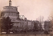
President Abraham Lincoln demanded that development on the United States Capitol vault keep during the American Civil War (1861).
During the 1830s, the District's southern domain of Alexandria went into financial decrease mostly because of disregard by Congress. The city of Alexandria was a significant market in the American slave exchange, and genius subjugation occupants expected that abolitionists in Congress would end subjection in the District, further discouraging the economy. Alexandria's residents requested of Virginia to reclaim the land it had given to frame the District, through a procedure known as retrocession.
The Virginia General Assembly casted a ballot in February 1846 to acknowledge the arrival of Alexandria and on July 9, 1846, Congress consented to restore all the region that had been surrendered by Virginia. In this manner, the District's present region comprises just of the part initially gave by Maryland.[33] Confirming the feelings of trepidation of genius bondage Alexandrians, the Compromise of 1850 prohibited the slave exchange the District, in spite of the fact that not subjugation itself.
The flare-up of the American Civil War in 1861 prompted the development of the government and striking development in the District's populace, including a huge convergence of liberated slaves . President Abraham Lincoln marked the Compensated Emancipation Act in 1862, which finished bondage in the District of Columbia and liberated around 3,100 subjugated people, nine months preceding the Emancipation Proclamation. In 1868, Congress conceded the District's African American male occupants the option to cast a ballot in metropolitan decisions.
Development and redevelopment
Groups encompassing the Lincoln Memorial Reflecting Pool during the March on Washington, 1963
By 1870, the District's populace had become 75% from the past statistics to almost 132,000 occupants Despite the city's development, Washington despite everything had soil streets and needed fundamental sanitation. A few individuals from Congress recommended moving the capital further west, yet President Ulysses S. Award wouldn't think about such a proposition.
Congress passed the Organic Act of 1871, which revoked the individual contracts of the urban communities of Washington and Georgetown, and made another regional government for the entire District of Columbia. President Grant designated Alexander Robey Shepherd to the situation of senator in 1873. Shepherd approved huge scope extends that enormously modernized the City of Washington, in any case bankrupted the District government. In 1874, Congress supplanted the regional government with a selected three-part Board of Commissioners.
The city's previously mechanized trolleys started administration in 1888 and produced development in zones of the District past the City of Washington's unique limits. Washington's urban arrangement was extended all through the District in the next decades. Georgetown's road framework and other regulatory subtleties were officially converged to those of the lawful City of Washington in 1895. Be that as it may, the city had helpless lodging conditions and stressed open works. The District was the primary city in the country to experience urban reestablishment ventures as a major aspect of the "City Beautiful development" in the mid 1900s.
Expanded bureaucratic spending because of the New Deal during the 1930s prompted the development of new government structures, dedications, and historical centers in the District, however the administrator of the House Subcommittee on District Appropriations Ross A. Collins from Mississippi legitimized slices to assets for government assistance and training for nearby occupants, saying that "my constituents wouldn't represent burning through cash on niggers."
World War II further expanded government movement, adding to the quantity of administrative representatives in the capital;[47] by 1950, the District's populace arrived at its pinnacle of 802,178 inhabitants
Principle article: War of 1812
Following their triumph at the Battle of Bladensburg, the British entered Washington, D.C., torching structures including the White House.
On August 24–25, 1814, in an attack known as the Burning of Washington, British powers attacked the capital during the War of 1812. The Capitol, Treasury, and White House were scorched and gutted during the assault . Most government structures were fixed rapidly; be that as it may, the Capitol was to a great extent under development at that point and was not finished in its present structure until 1868
Retrocession and the Civil War
See likewise: District of Columbia retrocession and Washington, D.C., in the American Civil War President Abraham Lincoln demanded that development on the United States Capitol vault keep during the American Civil War (1861).
During the 1830s, the District's southern domain of Alexandria went into financial decrease mostly because of disregard by Congress. The city of Alexandria was a significant market in the American slave exchange, and genius subjugation occupants expected that abolitionists in Congress would end subjection in the District, further discouraging the economy. Alexandria's residents requested of Virginia to reclaim the land it had given to frame the District, through a procedure known as retrocession.
The Virginia General Assembly casted a ballot in February 1846 to acknowledge the arrival of Alexandria and on July 9, 1846, Congress consented to restore all the region that had been surrendered by Virginia. In this manner, the District's present region comprises just of the part initially gave by Maryland.[33] Confirming the feelings of trepidation of genius bondage Alexandrians, the Compromise of 1850 prohibited the slave exchange the District, in spite of the fact that not subjugation itself.
The flare-up of the American Civil War in 1861 prompted the development of the government and striking development in the District's populace, including a huge convergence of liberated slaves . President Abraham Lincoln marked the Compensated Emancipation Act in 1862, which finished bondage in the District of Columbia and liberated around 3,100 subjugated people, nine months preceding the Emancipation Proclamation. In 1868, Congress conceded the District's African American male occupants the option to cast a ballot in metropolitan decisions.
Development and redevelopment
Groups encompassing the Lincoln Memorial Reflecting Pool during the March on Washington, 1963
By 1870, the District's populace had become 75% from the past statistics to almost 132,000 occupants Despite the city's development, Washington despite everything had soil streets and needed fundamental sanitation. A few individuals from Congress recommended moving the capital further west, yet President Ulysses S. Award wouldn't think about such a proposition.
Congress passed the Organic Act of 1871, which revoked the individual contracts of the urban communities of Washington and Georgetown, and made another regional government for the entire District of Columbia. President Grant designated Alexander Robey Shepherd to the situation of senator in 1873. Shepherd approved huge scope extends that enormously modernized the City of Washington, in any case bankrupted the District government. In 1874, Congress supplanted the regional government with a selected three-part Board of Commissioners.
The city's previously mechanized trolleys started administration in 1888 and produced development in zones of the District past the City of Washington's unique limits. Washington's urban arrangement was extended all through the District in the next decades. Georgetown's road framework and other regulatory subtleties were officially converged to those of the lawful City of Washington in 1895. Be that as it may, the city had helpless lodging conditions and stressed open works. The District was the primary city in the country to experience urban reestablishment ventures as a major aspect of the "City Beautiful development" in the mid 1900s.
Expanded bureaucratic spending because of the New Deal during the 1930s prompted the development of new government structures, dedications, and historical centers in the District, however the administrator of the House Subcommittee on District Appropriations Ross A. Collins from Mississippi legitimized slices to assets for government assistance and training for nearby occupants, saying that "my constituents wouldn't represent burning through cash on niggers."
World War II further expanded government movement, adding to the quantity of administrative representatives in the capital;[47] by 1950, the District's populace arrived at its pinnacle of 802,178 inhabitants
Social liberties and home standard time
Outer video 1960s Washington DC, 4K from 35mm Kinolibrary
The Twenty-third Amendment to the United States Constitution was sanctioned in 1961, giving the District three votes in the Electoral College for the appointment of president and VP, yet no democratic portrayal in Congress.
After the death of social liberties pioneer Dr. Martin Luther King, Jr., on April 4, 1968, riots broke out in the District, principally in the U Street, fourteenth Street, seventh Street, and H Street passages, focuses of dark private and business regions. The uproars seethed for three days until in excess of 13,600 government troops and D.C. Armed force National Guardsmen halted the viciousness. Numerous stores and different structures were singed; remaking was not finished until the late 1990s.
In 1973, Congress established the District of Columbia Home Rule Act, accommodating a chosen city hall leader and thirteen-part committee for the District. In 1975, Walter Washington turned into the principal chose and first dark civic chairman of the District.
Geology
Principle article: Geography of Washington, D.C.
Washington, D.C. is situated in Washington Metropolitan Area
Calvert
Charles
Frederick
Montgomery
Ruler George's
Alexandria
Alexandria
Arlington
Clarke
Fairfax
Fairfax
Fairfax County
Falls Church
Falls Church
Fauquier
Loudoun
Manassas
Manassas
Manassas Park
Manassas Park
Ruler William
Spotsylvania
Stafford
Fredericksburg
Fredericksburg
Warren
Washington
Washington
Jefferson
The Washington Metropolitan Area has a populace of 6,131,977, starting at 2014
Washington, D.C. is situated in the mid-Atlantic area of the U.S. East Coast. Because of the District of Columbia retrocession, the city has a complete region of 68.34 square miles (177.0 km2), of which 61.05 square miles (158.1 km2) is land and 7.29 square miles (18.9 km2) (10.67%) is water The District is flanked by Montgomery County, Maryland toward the northwest; Prince George's County, Maryland toward the east; Arlington County, Virginia toward the south; and Alexandria, Virginia toward the west.
The south bank of the Potomac River frames the District's outskirt with Virginia and has two significant tributaries: the Anacostia River and Rock Creek. Tiber Creek, a characteristic waterway that once gone through the National Mall, was completely encased underground during the 1870s.The rivulet additionally shaped a part of the now-filled Washington City Canal, which permitted section through the city to the Anacostia River from 1815 until the 1850s.[55] The Chesapeake and Ohio Canal begins in Georgetown and was utilized during the nineteenth century to sidestep the Little Falls of the Potomac River, situated at the northwest edge of Washington at the Atlantic Seaboard fall line.
The most noteworthy common height in the District is 409 feet (125 m) above ocean level at Fort Reno Park in upper northwest Washington.[57] The absolute bottom is ocean level at the Potomac River. The geographic focus of Washington is close to the crossing point of fourth and L Streets NW.
The District has 7,464 sections of land (30.21 km2) of parkland, about 19% of the city's complete zone and the second-most elevated rate among high-thickness U.S. urban areas. This factor added to Washington, D.C., being positioned as third in the country for park access and quality in the 2018 ParkScore positioning of the recreation center frameworks of the 100 most crowded urban communities in the United States, as per the charitable Trust for Public Land.
The National Park Service oversees a large portion of the 9,122 sections of land (36.92 km2) of city land possessed by the U.S. government. Rock Creek Park is a 1,754-section of land (7.10 km2) urban timberland in Northwest Washington, which broadens 9.3 miles (15.0 km) through a stream valley that cuts up the city. Built up in 1890, it is the nation's fourth-most established national park and is home to an assortment of plant and creature species, including raccoon, deer, owls, and coyotes. Other National Park Service properties incorporate the C&O Canal National Historical Park, the National Mall and Memorial Parks, Theodore Roosevelt Island, Columbia Island, Fort Dupont Park, Meridian Hill Park, Kenilworth Park and Aquatic Gardens, and Anacostia Park The D.C. Division of Parks and Recreation keeps up the city's 900 sections of land (3.6 km2) of athletic fields and play areas, 40 pools, and 68 entertainment centers.[67] The U.S. Branch of Agriculture works the 446-section of land (1.80 km2) U.S. National Arboretum in Northeast Washington.
Atmosphere
Washington is in the northern piece of the moist subtropical atmosphere zone (Köppen: Cfa). The Trewartha characterization is characterized as a maritime atmosphere (Do)Winters are typically crisp with light day off, summers are sweltering and damp. The District is in plant toughness zone 8a close to downtown, and zone 7b somewhere else in the city, showing a muggy subtropical atmosphere.
Spring and fall are gentle to warm, while winter is nippy with yearly snowfall averaging 15.5 inches (39 cm). Winter temperatures normal around 38 °F (3 °C) from mid-December to mid-February However, winter temperatures more than 60 °F (16 °C) are normal
Summers are sweltering and damp with a July every day normal of 79.8 °F (26.6 °C) and normal day by day relative moistness around 66%, which can cause moderate individual inconvenience The mix of warmth and dampness in the mid year brings visit tempests, some of which once in a while produce twisters in the region
Snowstorms influence Washington on normal once every four to six years. The most fierce tempests are designated "nor'easters", which regularly influence huge segments of the East Coast From January 27 to January 28, 1922, the city authoritatively got 28 inches (71 cm) of snowfall, the biggest blizzard since legitimate estimations started in 1885According to notes kept at that point, the city got somewhere in the range of 30 and 36 inches (76 and 91 cm) from a blizzard in January 1772
The Washington Monument, seen over the Tidal Basin during 2007's National Cherry Blossom Festival
Tropical storms (or their remainders) sporadically track through the zone in pre-fall and late-summer yet are frequently feeble when they arrive at Washington, somewhat because of the city's inland area Flooding of the Potomac River, nonetheless, brought about by a blend of elevated tide, storm flood, and spillover, has been known to cause broad property harm in the area of Georgetown.
Precipitation happens consistently.
Washington's atmosphere will develop hotter and precipitation will increment as the aftereffect of environmental change.
The most elevated recorded temperature was 106 °F (41 °C) on August 6, 1918, and on July 20, 1930. while the most reduced recorded temperature was −15 °F (−26 °C) on February 11, 1899, directly before the Great Blizzard of 1899.[76] During a regular year, the city midpoints around 37 days at or over 90 °F (32 °C) and 64 evenings at or beneath the freezing mark (32 °F or 0 °C).[72] all things considered, the main day with a base at or underneath freezing is November 18 and the most recent day is March 27
vte
Atmosphere information for Washington, D.C. (Reagan National Airport), 1981−2010 normals,[c] boundaries 1871−present[d]
Cityscape
See likewise: Streets and roadways of Washington, D.C.; Neighborhoods in Washington, D.C.; and List of tallest structures in Washington, D.C.
The L'Enfant Plan for Washington, D.C., as modified by Andrew Ellicott in 1792
Washington, D.C. is an arranged city. In 1791, President Washington appointed Pierre (Peter) Charles L'Enfant, a French-conceived modeler and city organizer, to plan the new capital. He enrolled Scottish assessor Alexander Ralston to help spread out the city plan The L'Enfant Plan included wide boulevards and roads transmitting out from square shapes, giving space to open space and finishing. He put together his structure with respect to plans of urban areas, for example, Paris, Amsterdam, Karlsruhe, and Milan that Thomas Jefferson had sent to him L'Enfant's plan additionally imagined a nursery lined "fabulous road" around 1 mile (1.6 km) long and 400 feet (120 m) wide in the territory that is presently the National Mall .President Washington excused L'Enfant in March 1792 because of contentions with the three chiefs named to oversee the capital's development. Andrew Ellicott, who had worked with L'Enfant looking over the city, was then entrusted with finishing the structure. In spite of the fact that Ellicott made corrections to the first plans—including changes to some road designs—L'Enfant is as yet credited with the general structure of the city.
A tall red block working in the focal point of a city horizon punctuated by steeples and other shorter structures
Development of the 12-story Cairo Apartment Building (1894) prodded assembling stature limitations
By the mid 1900s, L'Enfant's vision of an excellent national capital had gotten defaced by ghettos and arbitrarily positioned structures, including a railroad station on the National Mall. Congress framed an extraordinary advisory group accused of enhancing Washington's stylized center What got known as the McMillan Plan was settled in 1901 and included re-arranging the Capitol grounds and the National Mall, clearing ghettos, and building up another citywide park framework. The arrangement is thought to have generally protected L'Enfant's planned structure.
By law, Washington's horizon is low and rambling. The government Height of Buildings Act of 1910 permits structures that are no taller than the width of the neighboring road, in addition to 20 feet (6.1 m).[95] Despite mainstream thinking, no law has ever restricted structures to the stature of the United States Capitol Building or the 555-foot (169 m) Washington Monument,[61] which remains the District's tallest structure. City pioneers have condemned the stature limitation as an essential motivation behind why the District has constrained moderate lodging and traffic issues brought about by rural spread.
The District is partitioned into four quadrants of inconsistent zone: Northwest (NW), Northeast (NE), Southeast (SE), and Southwest (SW). The tomahawks bouncing the quadrants emanate from the U.S. Legislative hall building.[96] All street names incorporate the quadrant abbr
Culture
Principle article: Culture of Washington, D.C.
Tourist spots
See additionally: List of National Historic Landmarks in Washington, D.C.; National Register of Historic Places postings in Washington, D.C.; and List of galleries in Washington, D.C.
The Lincoln Memorial gets around 6,000,000 visits yearly.
The National Mall is a huge, open park in downtown Washington between the Lincoln Memorial and the United States Capitol. Given its unmistakable quality, the shopping center is frequently the area of political fights, shows, celebrations, and presidential introductions. The Washington Monument and the Jefferson Pier are close to the focal point of the shopping center, south of the White House. Likewise on the shopping center are the National World War II Memorial at the east finish of the Lincoln Memorial Reflecting Pool, the Korean War Veterans Memorial, and the Vietnam Veterans Memorial.[161]
Straightforwardly south of the shopping center, the Tidal Basin highlights lines of Japanese cherry trees.[162] The Franklin Delano Roosevelt Memorial, George Mason Memorial, Jefferson Memorial, Martin Luther King Jr. Commemoration, and the District of Columbia War Memorial are around the Tidal Basin.[161]
The National Archives houses a great many records critical to American history, including the Declaration of Independence, the Constitution, and the Bill of Rights.[163] Located in three structures on Capitol Hill, the Library of Congress is the biggest library complex on the planet with an assortment of in excess of 147 million books, original copies, and other materials.[164] The United States Supreme Court Building was finished in 1935; under the steady gaze of at that point, the court held meetings in the Old Senate Chamber of the Capitol.[165]
Exhibition halls
The Smithsonian Institution is the world's biggest exploration and exhibition hall complex.[166]
The Smithsonian Institution is an instructive establishment sanctioned by Congress in 1846 that keeps up the greater part of the country's legitimate historical centers and displays in Washington, D.C. The U.S. government halfway finances the Smithsonian, and its assortments are available to the open free of charge.[167] The Smithsonian's areas had a consolidated aggregate of 30 million visits in 2013. The most visited exhibition hall is the National Museum of Natural History on the National Mall.[168] Other Smithsonian Institution historical centers and displays on the shopping center are: the National Air and Space Museum; the National Museum of African Art; the National Museum of American History; the National Museum of the American Indian; the Sackler and Freer displays, which both spotlight on Asian workmanship and culture; the Hirshhorn Museum and Sculpture Garden; the Arts and Industries Building; the S. Dillon Ripley Center; and the Smithsonian Institution Building (otherwise called "The Castle"), which fills in as the foundation's headquarters.[169] The Smithsonian American Art Museum and the National Portrait Gallery are housed in the Old Patent Office Building, close to Washington's Chinatown.[170] The Renwick Gallery is authoritatively part of the Smithsonian American Art Museum however is in a different structure close to the White House. Other Smithsonian exhibition halls and displays include: the Anacostia Community Museum in Southeast Washington; the National Postal Museum close to Union Station; and the National Zoo in Woodley Park.[169]
The National Air and Space Museum is one of the world's most visited galleries.
The National Gallery of Art is on the National Mall close to the Capitol and highlights works of American and European workmanship. The display and its assortments are possessed by the U.S. government yet are not a piece of the Smithsonian Institution.[171] The National Building Museum, which possesses the previous Pension Building close to Judiciary Square, was sanctioned by Congress and hosts displays on engineering, urban arranging, and design.[172]
There are numerous private craftsmanship historical centers in the District of Columbia, which house significant assortments and displays open to the open, for example, the National Museum of Women in the Arts and The Phillips Collection in Dupont Circle, the main gallery of present day workmanship in the United States.[173] Other private galleries in Washington incorporate the Newseum, the O Street Museum Foundation, the International Spy Museum, the National Geographic Society Museum, the Marian Koshland Science Museum and the Museum of the Bible. The United States Holocaust Memorial Museum close to the National Mall looks after shows, documentation, and relics identified with the Holocaust.[174]
Expressions
Primary articles: Theater in Washington, D.C. what's more, Music of Washington, D.C.
The Kennedy Center for Performing Arts is home to the Washington National Opera and National Symphony Orchestra.
Washington, D.C., is a national community for expressions of the human experience. The John F. Kennedy Center for the Performing Arts is home to the National Symphony Orchestra, the Washington National Opera, and the Washington Ballet. The Kennedy Center Honors are granted every year to those in the performing expressions who have contributed significantly to the social existence of the United States.[175] The noteworthy Ford's Theater, site of the death of President Abraham Lincoln, keeps on working as a working exhibition space just as a museum.[176]
The Marine Barracks close to Capitol Hill houses the United States Marine Band; established in 1798, it is the nation's most seasoned proficient melodic organization.[177] American walk writer and Washington-local John Philip Sousa drove the Marine Band from 1880 until 1892.[178] Founded in 1925, the United States Navy Band has its central command at the Washington Navy Yard and performs at legitimate occasions and open shows around the city.[179] Washington has a solid neighborhood theater convention. Established in 1950, Arena Stage accomplished national consideration and prodded development in the city's free theater development that currently incorporates associations, for example, the Shakespeare Theater Company, Wooly Mammoth Theater Company, and the Studio Theatre.[180] Arena Stage opened its recently revamped home in the city's rising Southwest waterfront territory in 2010.[181] The GALA Hispanic Theater, presently housed in the noteworthy Tivoli Theater in Columbia Heights, was established in 1976 and is a National Center for the Latino Performing Arts.[182]
The U Street Corridor in Northwest D.C., known as "Washington's Black Broadway", is home to foundations like the Howard Theater, Bohemian Caverns, and the Lincoln Theater, which facilitated music legends, for example, Washington-local Duke Ellington, John Coltrane, and Miles Davis.[183] Washington has its own local music class called go-go; a post-funk, percussion-driven kind of mood and blues that was promoted in the late 1970s by D.C. band pioneer Chuck Brown.[184]
The District is a significant place for independent culture and music in the United States. The name Dischord Records, shaped by Ian MacKaye, frontman of Fugazi, was one of the most pivotal autonomous names in the beginning of 1980s punk and in the long run outside the box rock in the 1990s.[185] Modern other option and independent music settings like The Black Cat and the 9:30 Club carry well known acts to the U Street area.[186]
Sports
Primary article: Sports in Washington, D.C.
Nationals Park is the home of the Washington Nationals.
Washington is one of 13 urban areas in the United States with groups from every one of the four significant expert men's games and is home to one significant expert ladies' group. The Washington Wizards (National Basketball Association) and the Washington Capitals (National Hockey League) play at the Capital One Arena in Chinatown. The Washington Mystics (Women's National Basketball Association) play in the St. Elizabeths East Entertainment and Sports Arena. Nationals Park, which opened in Southeast D.C. in 2008, is home to the Washington Nationals (Major League Baseball). D.C. Joined together (Major League Soccer) plays at Audi Field. The Washington Redskins (National Football League) play at FedExField in close by Landover, Maryland.
Current D.C. groups have won a consolidated thirteen expert alliance titles: the Washington Redskins have won five (counting three Super Bowls during the 1980s);[187] D.C. Joined has won four;[188] and the Washington Wizards (at that point the Washington Bullets), Washington Capitals, Washington Mystics and Washington Nationals have each won a solitary championship.[189][190]
Other expert and semi-proficient groups in Washington include: DC Defenders (XFL), Old Glory DC (Major League Rugby), the Washington Kastles (World TeamTennis); the Washington D.C. Slayers (USA Rugby League); the Baltimore Washington Eagles (U.S. Australian Football League); the D.C. Divas (Independent Women's Football League); and the Potomac Athletic Club RFC (Rugby Super League). The William H.G. FitzGerald Tennis Center in Rock Creek Park has the Citi Open. Washington is likewise home to two significant yearly long distance race races: the Marine Corps Marathon, which is held each fall, and the Rock 'n' Roll USA Marathon held in the spring. The Marine Corps Marathon started in 1976 and is some of the time called "The People's Marathon" since it is the biggest long distance race that doesn't offer prize cash to participants.[191]
The District's four NCAA Division I groups, American Eagles, George Washington Colonials, Georgetown Hoyas and Howard Bison and Lady Bison, have a wide after. The Georgetown Hoyas men's b-ball group is the most prominent and furthermore plays at the Capital One Arena. From 2008 to 2012, the District facilitated a yearly school football bowl game at RFK Stadium, called the Military Bowl.[192] The D.C. territory is home to one provincial games TV station, Comcast SportsNet (CSN), situated in Bethesda, Maryland.
Media
Primary article: Media in Washington, D.C.
See additionally: List of papers in Washington, D.C. also, List of TV programs set in Washington, D.C.
The Washington Post Building on Franklin Square
Washington, D.C., is a conspicuous community for national and worldwide media. The Washington Post, established in 1877, is the most established and most-read neighborhood day by day paper in Washington.[193] "The Post", as it is prevalently called, is understand

التعبيراتالتعبيرات